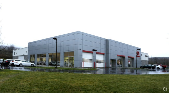
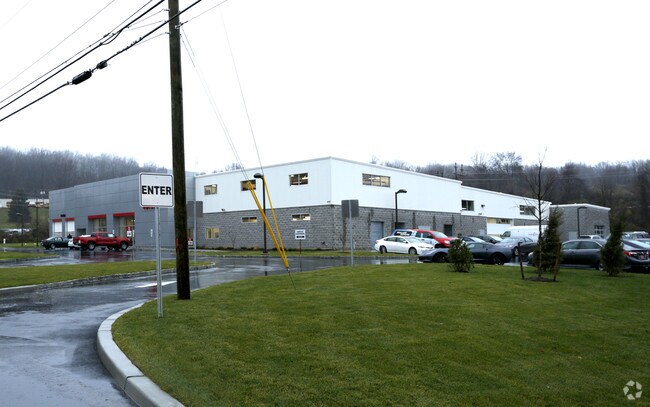
Property Record
2020 Route 31, Lebanon, NJ 08833

NEARBY LISTINGS FOR SALE OR LEASE
Property Detail
2020 Route 31
19-00003-0000-00005-01
ADDITIONAL LOTS: NOTICE RETURNED
Vehiclerentalsvehiclesales
Hunterdon
X
New Jersey
34019C0116F
5.1
2024
6.06 AC
2025
Route 78 West
010802
Northern New Jersey
25,440 SF
Newark, NJ-PA
DEMOGRAPHICS near 2020 Route 31
1 Mile
3 Mile
5 Mile
2024 Total Population
1,250
15,485
33,533
2029 Population
1,269
15,691
33,941
Pop Growth 2024-2029
+ 1.52%
+ 1.33%
+ 1.22%
Average Age
43
42
43
2024 Total Households
426
5,667
12,458
HH Growth 2024-2029
+ 1.88%
+ 1.68%
+ 1.48%
Median Household Inc
$121,499
$113,616
$118,335
Avg Household Size
2.50
2.40
2.50
2024 Avg HH Vehicles
2.00
2.00
2.00
Median Home Value
$335,897
$373,277
$404,654
Median Year Built
1956
1975
1977
Nearby Places
Map Layers
Map Styles
 Street
 Aerial
- Restaurants
- Banks
- Shops
- Fitness
- Groceries
PUBLIC TRANSPORTATION
COMMUTER RAIL
High Bridge (Raritan Valley Line - NJ Transit Commuter Rail (NJ Transit))
DRIVE
WALK
Distance
High Bridge (Raritan Valley Line - NJ Transit Commuter Rail (NJ Transit))
5 min
2.6 mi
Annandale (Raritan Valley Line - NJ Transit Commuter Rail (NJ Transit))
DRIVE
WALK
Distance
Annandale (Raritan Valley Line - NJ Transit Commuter Rail (NJ Transit))
8 min
4.5 mi
AIRPORT
Trenton Mercer
DRIVE
WALK
Distance
Trenton Mercer
50 min
33.0 mi
Lehigh Valley International
DRIVE
WALK
Distance
Lehigh Valley International
53 min
35.0 mi
Freight Ports
Maher Terminal
DRIVE
WALK
Distance
Maher Terminal
59 min
46.3 mi
Nearby Properties
Address
Land Use
TOTAL SIZE
Lot Size
Zoning
Address
Land Use
TOTAL SIZE
Lot Size
Zoning
1,740.74 AC
INS
Address
Land Use
TOTAL SIZE
Lot Size
Zoning
500.58 AC
WM
Address
Land Use
TOTAL SIZE
Lot Size
Zoning
3,432 SF
24.17 AC
OB3
Address
Land Use
TOTAL SIZE
Lot Size
Zoning
56.97 AC
R3
Address
Land Use
TOTAL SIZE
Lot Size
Zoning
255.40 AC
WM
Address
Land Use
TOTAL SIZE
Lot Size
Zoning
215.75 AC
RC
Address
Land Use
TOTAL SIZE
Lot Size
Zoning
2,526 SF
339.93 AC
RC
Address
Land Use
TOTAL SIZE
Lot Size
Zoning
Address
Land Use
TOTAL SIZE
Lot Size
Zoning
Address
Land Use
TOTAL SIZE
Lot Size
Zoning
1,120 SF
103 AC
INS
Address
Land Use
TOTAL SIZE
Lot Size
Zoning
Address
Land Use
TOTAL SIZE
Lot Size
Zoning
1.88 AC
OB-2
Address
Land Use
TOTAL SIZE
Lot Size
Zoning
52,594 SF
4.58 AC
GA
Address
Land Use
TOTAL SIZE
Lot Size
Zoning
10.18 AC
OB-4
Address
Land Use
TOTAL SIZE
Lot Size
Zoning
34.80 AC
ROM
Address
Land Use
TOTAL SIZE
Lot Size
Zoning
2,544 SF
562.37 AC
RC
Address
Land Use
TOTAL SIZE
Lot Size
Zoning
Address
Land Use
TOTAL SIZE
Lot Size
Zoning
8.97 AC
Address
Land Use
TOTAL SIZE
Lot Size
Zoning
47,400 SF
15.68 AC
I
Address
Land Use
TOTAL SIZE
Lot Size
Zoning
Address
Land Use
TOTAL SIZE
Lot Size
Zoning
14,526 SF
5.03 AC
R-2A
Address
Land Use
TOTAL SIZE
Lot Size
Zoning
11,584 SF
4.17 AC
C1
Address
Land Use
TOTAL SIZE
Lot Size
Zoning
7.14 AC
R-2A
Address
Land Use
TOTAL SIZE
Lot Size
Zoning
5.64 AC
C-4
Address
Land Use
TOTAL SIZE
Lot Size
Zoning
2.44 AC
C-4
Address
Land Use
TOTAL SIZE
Lot Size
Zoning
3.21 AC
C1
Address
Land Use
TOTAL SIZE
Lot Size
Zoning
6.87 AC
C
Address
Land Use
TOTAL SIZE
Lot Size
Zoning
19,899 SF
2.36 AC
C-4
Address
Land Use
TOTAL SIZE
Lot Size
Zoning
16,984 SF
1.97 AC
C-4
Address
Land Use
TOTAL SIZE
Lot Size
Zoning
1.78 AC
OB-2
The World's #1 Commercial Real Estate Marketplace
Connect with us
© 2026 CoStar Group
The information above has been obtained from sources believed reliable. While we do not doubt its accuracy we have not verified it and make no guarantee, warranty or representation about it. It is your responsibility to independently confirm its accuracy and completeness. Any projections, opinions, assumptions, or estimates used are for example only and do not represent the current or future performance of the property. The value of this transaction to you depends on tax and other factors which should be evaluated by your tax, financial, and legal advisors. You and your advisors should conduct a careful, independent investigation of the property to determine to your satisfaction the suitability of the property for your needs.